


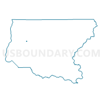
McDivitt Voting District, King County, Washington
About
Outline

Summary
| Unique Area Identifier | 685461 |
| Name | McDivitt Voting District |
| County | King County |
| State | Washington |
| Area (square miles) | 0.17 |
| Land Area (square miles) | 0.04 |
| Water Area (square miles) | 0.14 |
| % of Land Area | 22.18 |
| % of Water Area | 77.82 |
| Latitude of the Internal Point | 47.54219500 |
| Longtitude of the Internal Point | -122.19647240 |
Maps


Graphs
Select a template below for downloading or customizing gragh for McDivitt Voting District, King County, Washington


Neighbors
Neighoring Voting District (by Name) Neighboring Voting District on the Map
- BEL 41-2556 Voting District, King County, WA
- BEL 41-2906 Voting District, King County, WA
- M-I 41-0779 Voting District, King County, WA
- NEW 41-3261 Voting District, King County, WA
- RNT 41-0995 Voting District, King County, WA
- RNT 41-1018 Voting District, King County, WA
- Water: Lake Washington Leg 41, King County, WA
Top 10 Neighboring County Subdivision (by Population) Neighboring County Subdivision on the Map
Top 10 Neighboring Place (by Population) Neighboring Place on the Map
- Bellevue city, WA (122,363)
- Renton city, WA (90,927)
- Mercer Island city, WA (22,699)
- Newcastle city, WA (10,380)
Top 10 Neighboring Unified School District (by Population) Neighboring Unified School District on the Map
Top 10 Neighboring State Legislative District Lower Chamber (by Population) Neighboring State Legislative District Lower Chamber on the Map
Top 10 Neighboring State Legislative District Upper Chamber (by Population) Neighboring State Legislative District Upper Chamber on the Map
Top 10 Neighboring 111th Congressional District (by Population) Neighboring 111th Congressional District on the Map
Top 10 Neighboring Census Tract (by Population) Neighboring Census Tract on the Map
- Census Tract 247.02, King County, WA (7,058)
- Census Tract 239, King County, WA (6,924)
- Census Tract 246.01, King County, WA (4,302)